Reference-map notice: Flood and Landslide Susceptibility Zone labels below are visual interpretations of the supplied MGB map PNGs. They are reference information, not coordinate-level records generated by Import & AutoML.
Municipality
City of Balanga
2016 · 🌊 Flood Dominant
Samal
2023 · 🌊 Flood Dominant
Hermosa
2022 · ⚠️ Dual Hazard
Abucay
2021 · ⛰️ Landslide Dominant
Bagac
2020 · ⛰️ Landslide Dominant
Mariveles
2019 · ⛰️ Landslide Dominant
Dinalupihan
2018 · ✅ Low Hazard
Limay
2019 · ⚠️ Dual Hazard
Orion
2020 · ⛰️ Landslide Dominant
Orani
2024 · ✅ Low Hazard
Pilar
2018 · ⛰️ Landslide Dominant
Morong
2019 · ⛰️ Landslide Dominant
100%
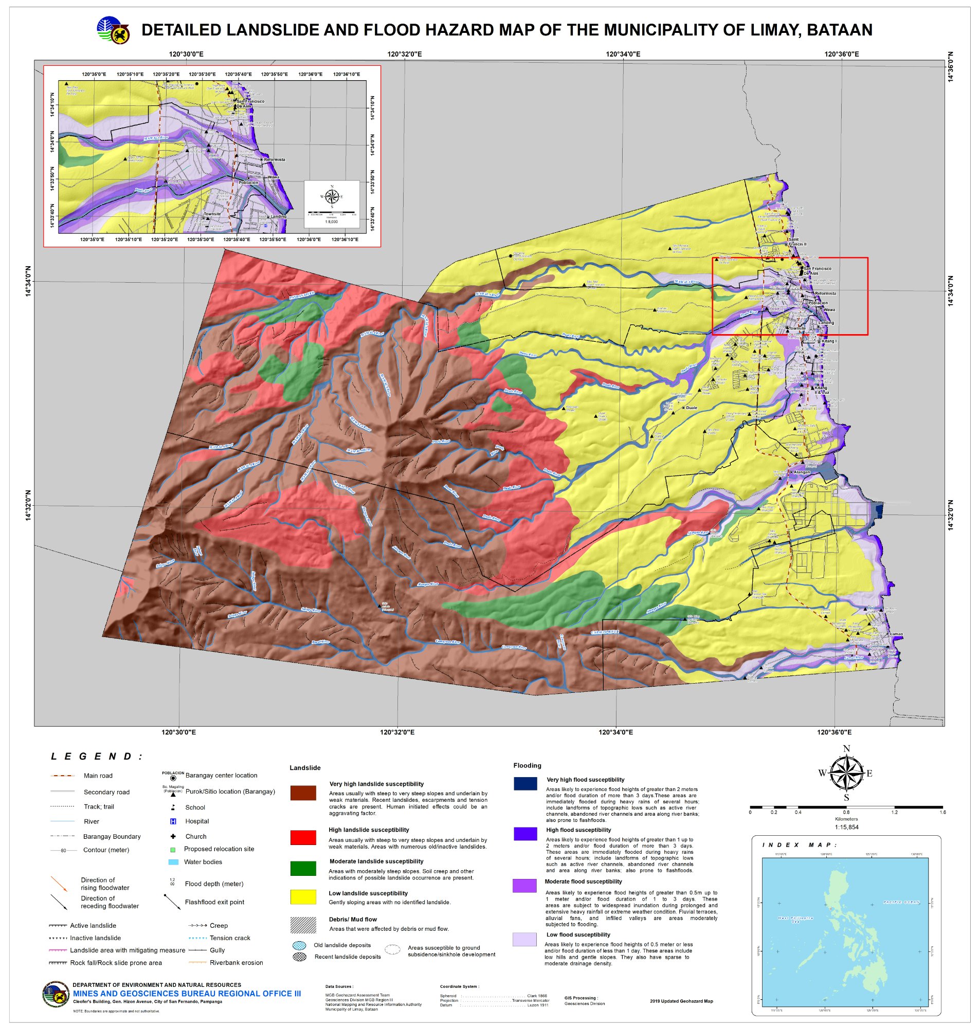
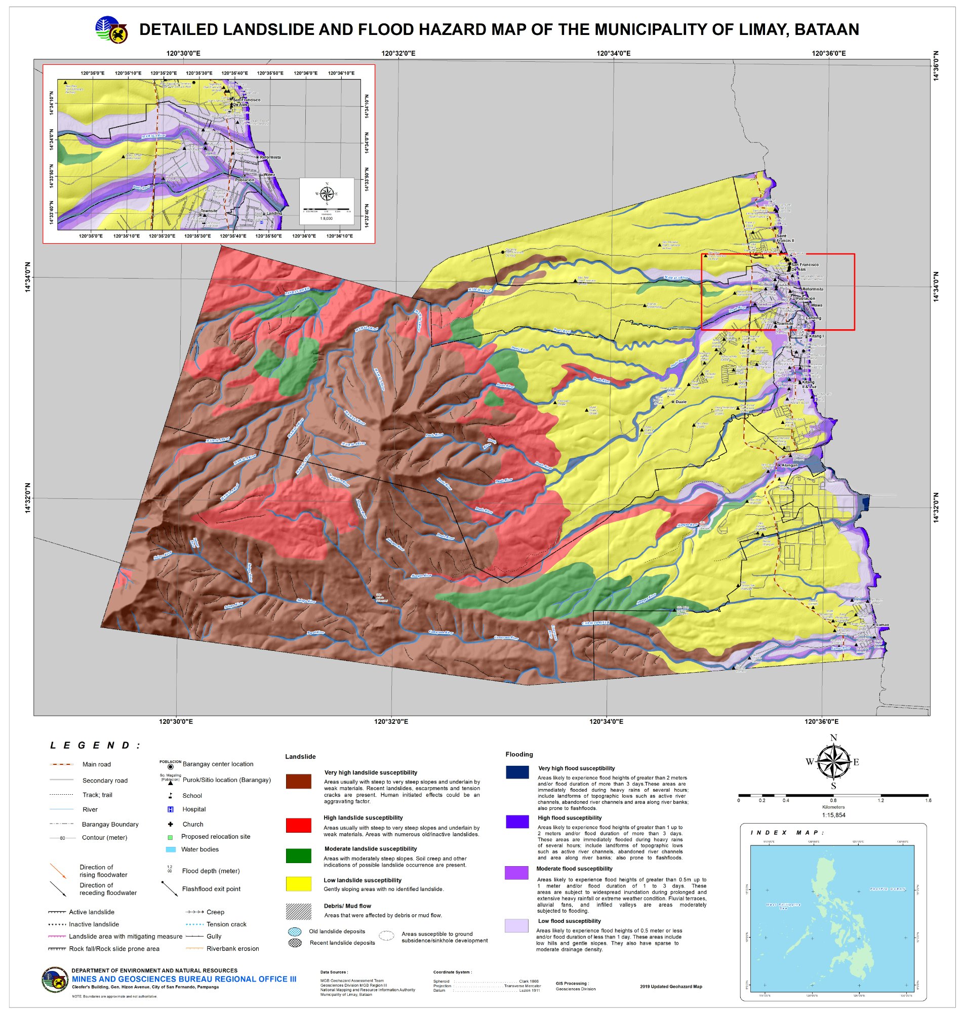
Flood:High – Moderate
Landslide:Very High – High
Res:1904×2000
🖱 Scroll/pinch = Zoom · Drag = Pan · ⛶ Full screen deep-zoom
🌊
Flood Susceptibility
High – Moderate
Purple/blue zones. Flood depths & duration vary by level. Very High = >2m lasting >3 days during extreme events. Includes active river channels, abandoned channels & topographic lows along river banks.
⛰️
Landslide Susceptibility
Very High – High
Brown/red zones on steep slopes underlain by weak materials. Evidence includes recent landslides, scarps, tension cracks, gullies. Human-initiated effects (road cuts, excavation) are aggravating factors.
🤖
Flood Exposure Summary
0 / 12 Brgy
0 of 12 barangays fall under the actual Moderate to High / High flood susceptibility classes from the validated Excel file. Municipality classification: LOW. Dominant hazard: ⚠️ Dual Hazard.
🌊 Flood Susceptibility Zones — Limay
Zone 1: LISP Industrial Coast
High Flood
💧 Depth: 1–2m
⏱ Duration: >3 days
Affected Barangays:
Francisco
Reformista
Townsite
Zone 2: Poblacion Lowland
Moderate Flood
💧 Depth: 0.5–1m
⏱ Duration: 1–3 days
Affected Barangays:
Alangan
Duale
⛰️ Landslide Susceptibility Zones — Limay
Zone 1: Western Mountains
Very High LS
🪨 Type: Rock falls + debris flows along fault
Affected Barangays:
Kitang 1
Kitang 2
Lamao
Zone 2: Foot Slopes
High LS
🪨 Type: Rotational slides + creep
Affected Barangays:
Plateau
Townsite upland
📋 Location Data Details — Limay
Limay hosts major industrial estates along its eastern coastal corridor and mountainous terrain to the west. Based on the validated Excel counts, none of its 12 barangays fall under the Moderate to High / High flood classes.
📊 All Municipalities — Comparative Overview
City of Balanga
14/24
Samal
9/14
Hermosa
6/15
Abucay
4/9
Bagac
5/14
Mariveles
1/13
Dinalupihan
15/46
Limay
0/12
Orion
3/23
Orani
8/23
Pilar
2/19
Morong
0/5
100%
Scroll or pinch to zoom · Drag to pan anywhere