Reference-map notice: Flood and Landslide Susceptibility Zone labels below are visual interpretations of the supplied MGB map PNGs. They are reference information, not coordinate-level records generated by Import & AutoML.
Municipality
City of Balanga
2016 · 🌊 Flood Dominant
Samal
2023 · 🌊 Flood Dominant
Hermosa
2022 · ⚠️ Dual Hazard
Abucay
2021 · ⛰️ Landslide Dominant
Bagac
2020 · ⛰️ Landslide Dominant
Mariveles
2019 · ⛰️ Landslide Dominant
Dinalupihan
2018 · ✅ Low Hazard
Limay
2019 · ⚠️ Dual Hazard
Orion
2020 · ⛰️ Landslide Dominant
Orani
2024 · ✅ Low Hazard
Pilar
2018 · ⛰️ Landslide Dominant
Morong
2019 · ⛰️ Landslide Dominant
100%
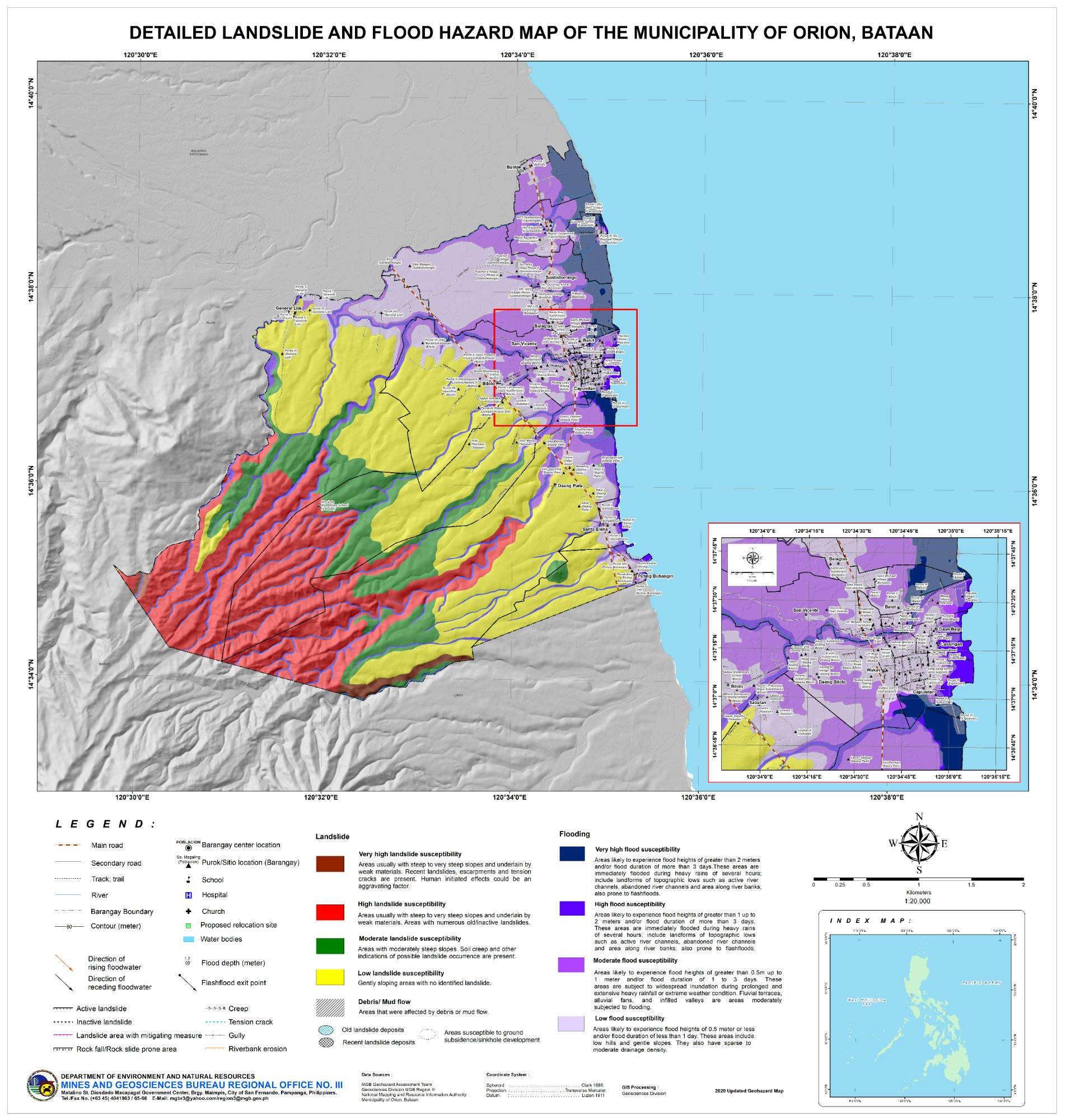
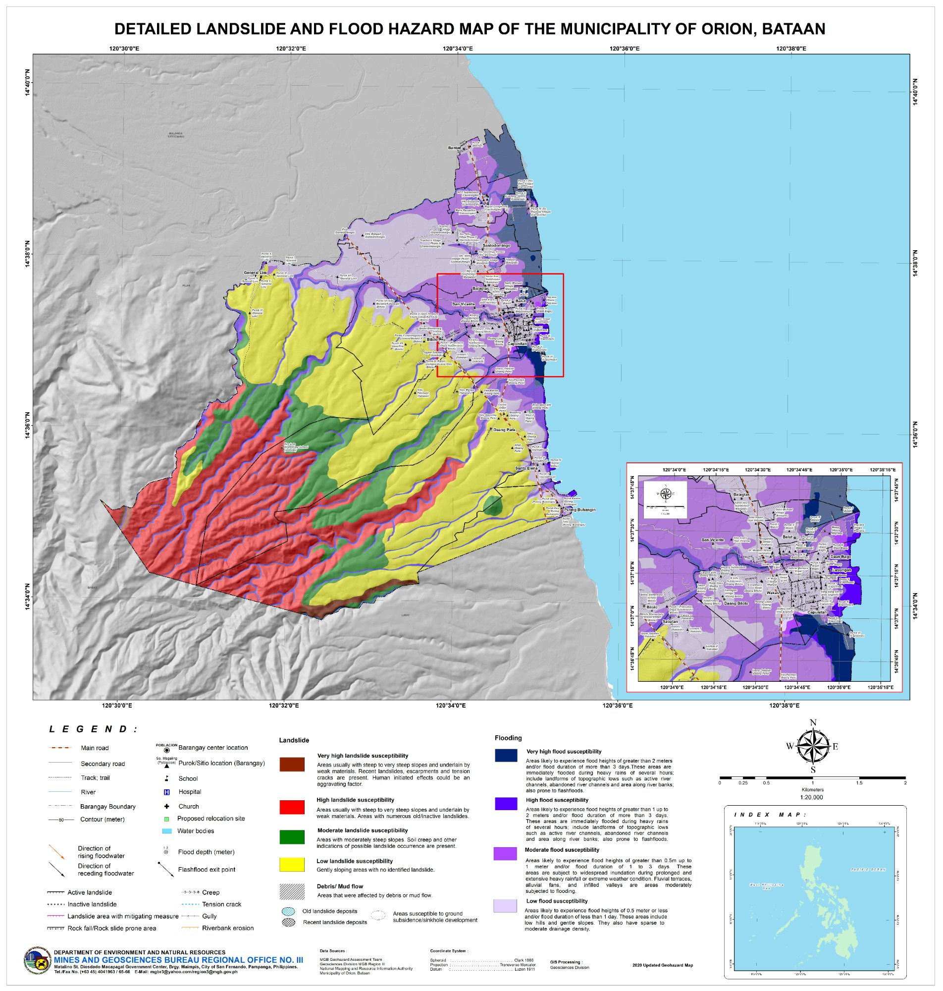
Flood:Low – Moderate
Landslide:High – Very High
Res:1904×2000
🖱 Scroll/pinch = Zoom · Drag = Pan · ⛶ Full screen deep-zoom
🌊
Flood Susceptibility
Low – Moderate
Purple/blue zones. Flood depths & duration vary by level. Very High = >2m lasting >3 days during extreme events. Includes active river channels, abandoned channels & topographic lows along river banks.
⛰️
Landslide Susceptibility
High – Very High
Brown/red zones on steep slopes underlain by weak materials. Evidence includes recent landslides, scarps, tension cracks, gullies. Human-initiated effects (road cuts, excavation) are aggravating factors.
🤖
Flood Exposure Summary
3 / 23 Brgy
3 of 23 barangays fall under the actual Moderate to High / High flood susceptibility classes from the validated Excel file. Municipality classification: LOW. Dominant hazard: ⛰️ Landslide Dominant.
🌊 Flood Susceptibility Zones — Orion
Zone 1: Manila Bay Edge
Low Flood
💧 Depth: <0.5m
⏱ Duration: <1 day
Affected Barangays:
Arellano
Bilolo
Calumpang
Zone 2: River Flats
Moderate Flood
💧 Depth: 0.5–1m
⏱ Duration: 1–3 days
Affected Barangays:
Daang Bago
Kaput
Puting Buhangin
⛰️ Landslide Susceptibility Zones — Orion
Zone 1: Bataan Natural Park Edge
Very High LS
🪨 Type: Rock falls + deep-seated slides
Affected Barangays:
Don Basilio
Quiling Sur
Zone 2: Transitional Belt
High LS
🪨 Type: Inactive old slides
Affected Barangays:
Diwa
Mabatang
Sta. Anastacia
📋 Location Data Details — Orion
Orion's eastern coastal strip has generally lower flood susceptibility, while the western mountainous zone carries higher landslide susceptibility. Based on the validated Excel counts, 3 of 23 barangays fall under the Moderate to High / High flood classes.
📊 All Municipalities — Comparative Overview
City of Balanga
14/24
Samal
9/14
Hermosa
6/15
Abucay
4/9
Bagac
5/14
Mariveles
1/13
Dinalupihan
15/46
Limay
0/12
Orion
3/23
Orani
8/23
Pilar
2/19
Morong
0/5
100%
Scroll or pinch to zoom · Drag to pan anywhere